|
Check out
Summit County Explorer's
"I LIKE TO BE ON TOP"
T-shirt and other merchandise!
Click logo above
|
|
This is a great family hike!
The well marked trail begins through open meadows that reaches a
pine forest after about 1.3 miles.
Here you begin the steepest part of your
climb to the ridge on top. In July and August you will be
treated to beautiful wildflower displays.
Once on the ridge, look for Mt.
Holy Cross off to the southwest, the Gore Range to the north and
the Tenmile Range to the east. |

|

Looking northwest as you begin your ascent to the trails summit. |
The Copper mountain ski resort is visible to the southeast. Upon
the ridge hikers can explore interesting rock formations and
numerous places to picnic or just enjoy the view.
To enjoy identifying various landmarks, pick up a copy of
National Geographic's Trails Illustrated Topo Map of Vail and
Frisco at Weber's bookstore in Breckenridge or just follow the
links on our home page to place your order.
This is certainly a great hike for the entire family - get out
there and hit the trail! |

Taking
a breather further along the trail
|

Great
view of Mt. Holy Cross from the Shrine Trail Summit |

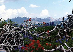
Summer
wildflowers are plentiful along the trailside.
|
|