|

|
 |
SUMMIT MOUNTAIN
RENTALS
A
full-service property management company offering top quality
Breckenridge and Frisco vacation lodging in Summit County,
Colorado. Locally owned and operated, specializing in
personalized service & attention for our guests, and we�re happy
to help you find the perfect vacation rental for your mountain
getaway.
Click to visit
SummitRentals.com today! |
|
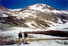
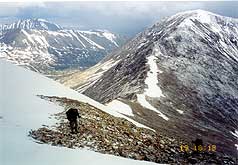
Below:
Reaching the mine ruins, a look back down at Kite Lake and where
we had come from... |
|
|

Check out Summit County Explorer's
"I LIKE TO BE ON TOP"
T-shirt and gear!
Click logo above
|
|
|
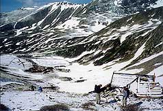
Description:
The trail begins just to the right (north) of Kite Lake.
From this magnificent trailhead it is not hard to imagine
yourself at
the base camp on Everest- hey altitude is intoxicating and why
spend
$65,000 when you can use a little imagination?? As you pass the
lake,
you will see a collapsed cabin and other mining ruins directly
in front
of you. At the ruins you can look back down the valley for a
view of the
lake and an appreciation of the reason for its name.
|
 |
 |
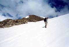
From the ruins you begin a series of
clearly marked switchbacks that begin a steep assault on the
summit. Eventually, they take you to the ridge of the saddle
between Mt. Democrat and Mt. Cameron where you have about
another .5 miles to the top.
The significant elevation gain of
over 1,000' ft. per mile will make this seem like more than a
two mile hike. Views of Mt. Cameron, Bross and Lincoln (all
fourteeners) will reward the diligent hiker. |
 |
|
Above: Steep grades are never captured successfully in photos.
Don't believe this was steep? Climb up and see for yourself!! |
|
|
|
|
|
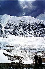
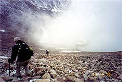
Above:
Beautiful Skies! Looking back down to the valley (Kite Lake
would be on your right - outside of the picture frame. |
|
|
|
|
|
 |
On our recent spring adventure, we were chased from the mountain
just a few hundred feet from the summit by a "perfect storm"
that
converged from all directions. Thunder, lightening and hail
resulted in
a prudent decision to hurriedly descend and seek the comforting
ambiance
of a coffee shop in Alma! |
 |
|
|
|
|
|
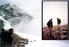
Above: Closing in on our final ascent to the summit, we make it
to this plateau only to view the fact that we have two storm
fronts converging directly upon us. |
Above: This
shot does not look too ominous, but again, you cannot feel the
wind and hear the thunder that convinced us to turn around. |
|
|
|
|
 |
Hey,
Summit County Explorers
"like to be on
top" but enjoy being alive even more!!!
See you on our next adventure!! |
 |
|
|
|
|
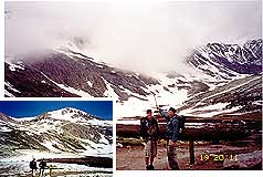
Above:
You can see the storm clouds coming in from the right. What you
cannot see is the storm behind us (approaching from the left)
Inset - we are pounded by blistering winds and hail! |
Survival! We made it down, reeling from the excitement of the
storm. Compare the photo of when we started (inset) to when we
finally made it down... |
|
|
|
|
|
Just another word of caution:
compare the bottom photos with the top. The weather
changes quickly at this high altitude! When you see approaching cloud cover
and/or hear distant thunder, we urge you to descend to safety
immediately. Safety comes first, its best to live to climb
another day! |
|
|
|
|
|
|
|
|
|
|

|
beginner
|
|
intermediate
|
|
advanced
|
|
|
|
Black
Powder Pass
|
|
Mohawk
Lake
|
|
Quandary
Peak
14,265' |
|
|
|
Lily
Pad
|
|
Chihuahua
Gulch
|
|
Lincoln & Bross
14,291' / 14,177' |
|
|
|
St.
John's
|
|
Mt.
Royal
|
|
Bierstadt Peak
14,060' |
|
|
|
Mayflower Gulch |
|
Wheeler Lakes |
|
Willow & Salmon Lakes |
|
|
|
Loveland Pass |
|
Radical Hill Trail |
|
Upper Crystal Lake |
|
|
|
Salt Lick
Trail |
|
McCullough Gulch |
|
Gray's & Torrey's
14,278' / 14,267' |
|
|
|
Mesa
Cortina Trail |
|
Mt.
Sniktau |
|
Mt. Democrat
14,152' |
|
|
|
St. Mary's Glacier |
|
North
Ten Mile Trail |
|
Mt.
Victoria |
|
|
|
Sally Barber Mine |
|
Willow
Falls |
|
Mt.
Elbert
14,433' |
|
|
|
Oro
Grande Trail |
|
Eaglesmere Lakes |
|
Buffalo Mountain
12,777' |
|
|
|
Meadow Creek-Salt Lick |
|
Mosquito Pass |
|
Eccles Pass |
|
|
|
Shrine Mountain
Trail |
|
Webster Pass |
|
Mt. Huron 14,003' |
|
|
|
Ptarmigan Trail |
|
Ptarmigan via Wilder Gulch |
|
|
|
|
|
Peaks Tr. Barton Gulch |
|
Wheeler
Lake - Park County |
|
|
|
|
|
Hoosier Pass Loop |
|
Lenawee
Trail |
|
|
|
|
|
Spruce Creek Loop |
NEW! |
Nightmare on Baldy Mine |
|
|
|
|
NEW! |
Tenderfoot
Mountain Trail |
|
|
|
|
|
|
|
Did You find our FREE trail descriptions useful?
Please donate a buck or
two.
We appreciate your support! |
 |
|
|
|
|
|
|
|
|
|
|
|
|
|