|
|
 |
|
Below:
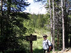
Peaks trail begins on your left as the road to Miner's Creek
continues to the right - you'll see a sign for miner's creek
road on the right (not in the photo) |
|
|

|
|
Description:
This is a great hike for the entire family and is best early (June)
or late (Sept.-Oct.) in the season when temperatures are cool. The
trail ascends gently along a bubbling stream that affords glimpses
of brook trout, beaver dams and gentle falls. At 1.5 miles you come
to the intersection with the Gold Hill Trail that enters on your
left (east).
The entire stroll provides great glimpses of
the Ten Mile Range and Peak One. Nicely cushioned with pine needles,
the trail is soft and comfortable. Keep alert for mountain bikers
who sometimes approach quickly and unexpectedly. |

|
|
|
|
|
 |
At two miles you come to another
intersection that marks the direction to Wheeler Trail and Copper
Mountain off to the west.
Before reaching the N. Barton Gulch stream
crossing you come to an open area that reveals beautiful views of
Mt. Baldy and Guyot off in the direction of Breckenridge
(southeast). You see route nine in the distance and this provides a
great place for lunch or a snack.
This hike ends at the stream crossing (you'll
see irrigation ditches on your right as you approach) and you turn
around and retrace your steps. |
 |
|
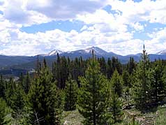
Above: Peak One and the Ten Mile Range are off to your west. |
|
Above:
Early on the trail you can take a quick look back to see Buffalo
Mountain. |
|
|
|
|
|
|
|
|
|
 |

"I LIKE TO BE ON TOP"
t-shirt and other merchandise
Click logo above |
|
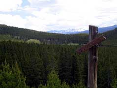
Above:
Irrigation is on your right as you approach the stream crossing
at North Barton Gulch. |
|
|
|
|
|
|
|
|
|
|
|
|
|
|

|
beginner
|
|
intermediate
|
|
advanced
|
|
|
|
Black
Powder Pass
|
|
Mohawk
Lake
|
|
Quandary
Peak
14,265' |
|
|
|
Lily
Pad
|
|
Chihuahua
Gulch
|
|
Lincoln & Bross
14,291' / 14,177' |
|
|
|
St.
John's
|
|
Mt.
Royal
|
|
Bierstadt Peak
14,060' |
|
|
|
Mayflower Gulch |
|
Wheeler Lakes |
|
Willow & Salmon Lakes |
|
|
|
Loveland Pass |
|
Radical Hill Trail |
|
Upper Crystal Lake |
|
|
|
Salt Lick
Trail |
|
McCullough Gulch |
|
Gray's & Torrey's
14,278' / 14,267' |
|
|
|
Mesa
Cortina Trail |
|
Mt.
Sniktau |
|
Mt. Democrat
14,152' |
|
|
|
St. Mary's Glacier |
|
North
Ten Mile Trail |
|
Mt.
Victoria |
|
|
|
Sally Barber Mine |
|
Willow
Falls |
|
Mt.
Elbert
14,433' |
|
|
|
Oro
Grande Trail |
|
Eaglesmere Lakes |
|
Buffalo Mountain
12,777' |
|
|
|
Meadow Creek-Salt Lick |
|
Mosquito Pass |
|
Eccles Pass |
|
|
|
Shrine Mountain
Trail |
|
Webster Pass |
|
Mt. Huron 14,003' |
|
|
|
Ptarmigan Trail |
|
Ptarmigan via Wilder Gulch |
|
|
|
|
|
Peaks Tr. Barton Gulch |
|
Wheeler
Lake - Park County |
|
|
|
|
|
Hoosier Pass Loop |
|
Lenawee
Trail |
|
|
|
|
|
Spruce Creek Loop |
NEW! |
Nightmare on Baldy Mine |
|
|
|
|
NEW! |
Tenderfoot
Mountain Trail |
|
|
|
|
|
|
|
Did You find our FREE trail descriptions useful?
Please donate a buck or
two.
We appreciate your support! |
 |
|
|
|
|
|
|
|
|
|
|
|
|
|