|

|
 |
|
Below:
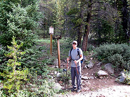
Starting out at the trailhead |
|
|

Check out Summit County Explorer's
"I LIKE TO BE ON TOP"
T-shirt and gear!
Click logo above
|
|
|
The first mile or so
is a moderately strenuous, steady uphill climb through an aspen
and evergreen forest. There are frequent views across the Peru
Creek and of Lake Dillon off to the west. As you emerge on to
the tundra, take advantage of the opportunity to scramble up
some rock croppings for outstanding views. On the tundra the
trail serpentines above Thurman Gulch toward your destination
which is the summit of the pass leading to Arapaho Basin ski
area off to the north. As the trail approaches the pass, it
clings to the side of the gulch and passes by the ruins of a
19th century silver mine at approximately the three mile mark.
|
|
 |
The mine is on your
right as you begin the final ascent to the pass and your
destination at about 12,530'.
You'll know you
have arrived when you see the ski lifts of Arapaho basin!
|
 |
|
|
|
|
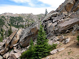
Above:
After emerging from the treeline, you begin
to work your way back towards the gulch. |
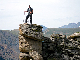
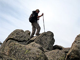
Above:
one of the many vistas,
having fun just climbing around! |
|
|
|
|
 |
A good place to
escape the wind and enjoy lunch is the rock cropping near the
"out of bounds" markers of the ski resort.
Enjoy the views
prior to re-tracing your steps back to the trailhead.
|
 |
|
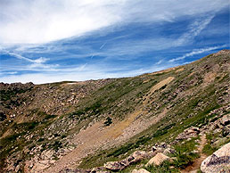
Above:
working your way around the gulch up towards the ridge |
|
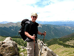
Above:
Standing on the ridge over looking Arapahoe Basin Ski Resort |
|
For more detailed information on the
history and topography of this area we suggest a visit to
Weber's Bookstore in Breckenridge where you can pick up a copy
of "The New Summit Hiker" by Mary Ellen Gilliland. |
|
|
|
|
|
|
|
|
|
|

|
beginner
|
|
intermediate
|
|
advanced
|
|
|
|
Black
Powder Pass
|
|
Mohawk
Lake
|
|
Quandary
Peak
14,265' |
|
|
|
Lily
Pad
|
|
Chihuahua
Gulch
|
|
Lincoln & Bross
14,291' / 14,177' |
|
|
|
St.
John's
|
|
Mt.
Royal
|
|
Bierstadt Peak
14,060' |
|
|
|
Mayflower Gulch |
|
Wheeler Lakes |
|
Willow & Salmon Lakes |
|
|
|
Loveland Pass |
|
Radical Hill Trail |
|
Upper Crystal Lake |
|
|
|
Salt Lick
Trail |
|
McCullough Gulch |
|
Gray's & Torrey's
14,278' / 14,267' |
|
|
|
Mesa
Cortina Trail |
|
Mt.
Sniktau |
|
Mt. Democrat
14,152' |
|
|
|
St. Mary's Glacier |
|
North
Ten Mile Trail |
|
Mt.
Victoria |
|
|
|
Sally Barber Mine |
|
Willow
Falls |
|
Mt.
Elbert
14,433' |
|
|
|
Oro
Grande Trail |
|
Eaglesmere Lakes |
|
Buffalo Mountain
12,777' |
|
|
|
Meadow Creek-Salt Lick |
|
Mosquito Pass |
|
Eccles Pass |
|
|
|
Shrine Mountain
Trail |
|
Webster Pass |
|
Mt. Huron 14,003' |
|
|
|
Ptarmigan Trail |
|
Ptarmigan via Wilder Gulch |
|
|
|
|
|
Peaks Tr. Barton Gulch |
|
Wheeler
Lake - Park County |
|
|
|
|
|
Hoosier Pass Loop |
|
Lenawee
Trail |
|
|
|
|
|
Spruce Creek Loop |
NEW! |
Nightmare on Baldy Mine |
|
|
|
|
NEW! |
Tenderfoot
Mountain Trail |
|
|
|
|
|
|
|
Did You find our FREE trail descriptions useful?
Please donate a buck or
two.
We appreciate your support! |
 |
|
|
|
|
|
|
|
|
|
|
|
|
|