|

|
 |
 
|
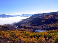
Below:
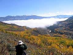
Fog over Green Mountain Reservoir over to the East. |
|
|

Check out Summit County Explorer's
"I LIKE TO BE ON TOP"
T-shirt and gear!
Click logo above
|
|
|
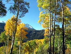
Views of the Williams Fork Range and Eagles
Nest Peak (13,342') continue to appear until you enter a thick,
dark, green pine forest after about two miles.
At 2.8 miles you will encounter a sign where the Eaglesmere trail meets the Gore
Range trail. You turn right here for what will prove to be the
longest half mile of the hike.
A fairly steep ascent suddenly changes to a downhill trek that will
lead to another sign for the Gore Range trail.
|
|
 |
The sign shows the trail going right and left
but IGNORE it
and go STRAIGHT to the lakes which are only a couple hundred yards
ahead.
There are two lakes, the smaller one just north of the
larger.
|
 |
|
|
|
|
|
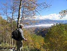
Above:
Another vista from the trail as you climb above Lower Cataract
lake. |
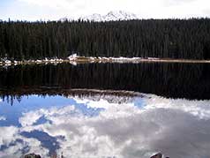
Above: The largest of the two lakes |
|
|
|
|
 |
Bring along a copy of National Geographic's Topo Map of
"Green Mountain Reservoir, Ute Pass" to help you identify key
landmarks.
For the first mile or so, you will
occasionally here the sound of Cataract Falls as they plunge into
Lower Cataract lake.
|
 |
|
|
|
|
|
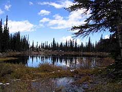
Above: The smaller of the two lakes, looking north between the
two. |
|
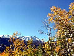
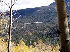
Above: A
view to the east to William Fork Mountains |
|
|
|
|
 |
See our description of the Lower Cataract lake
hike for a view of the falls.
The Eaglesmere Lakes hike is a great hike
anytime but especially colorful in the fall! |
 |
|
|
|
|
|
Above:
A view of Lower Cataract Lake at the beginning of the trail. |
Above: A view of Tippery Lake looking South (center of photo). |
|
|
|
|
|
|
|
|
|
|
|
|
|
|

|
beginner
|
|
intermediate
|
|
advanced
|
|
|
|
Black
Powder Pass
|
|
Mohawk
Lake
|
|
Quandary
Peak
14,265' |
|
|
|
Lily
Pad
|
|
Chihuahua
Gulch
|
|
Lincoln & Bross
14,291' / 14,177' |
|
|
|
St.
John's
|
|
Mt.
Royal
|
|
Bierstadt Peak
14,060' |
|
|
|
Mayflower Gulch |
|
Wheeler Lakes |
|
Willow & Salmon Lakes |
|
|
|
Loveland Pass |
|
Radical Hill Trail |
|
Upper Crystal Lake |
|
|
|
Salt Lick
Trail |
|
McCullough Gulch |
|
Gray's & Torrey's
14,278' / 14,267' |
|
|
|
Mesa
Cortina Trail |
|
Mt.
Sniktau |
|
Mt. Democrat
14,152' |
|
|
|
St. Mary's Glacier |
|
North
Ten Mile Trail |
|
Mt.
Victoria |
|
|
|
Sally Barber Mine |
|
Willow
Falls |
|
Mt.
Elbert
14,433' |
|
|
|
Oro
Grande Trail |
|
Eaglesmere Lakes |
|
Buffalo Mountain
12,777' |
|
|
|
Meadow Creek-Salt Lick |
|
Mosquito Pass |
|
Eccles Pass |
|
|
|
Shrine Mountain
Trail |
|
Webster Pass |
|
Mt. Huron 14,003' |
|
|
|
Ptarmigan Trail |
|
Ptarmigan via Wilder Gulch |
|
|
|
|
|
Peaks Tr. Barton Gulch |
|
Wheeler
Lake - Park County |
|
|
|
|
|
Hoosier Pass Loop |
|
Lenawee
Trail |
|
|
|
|
|
Spruce Creek Loop |
NEW! |
Nightmare on Baldy Mine |
|
|
|
|
NEW! |
Tenderfoot
Mountain Trail |
|
|
|
|
|
|
|
Did You find our FREE trail descriptions useful?
Please donate a buck or
two.
We appreciate your support! |
 |
|
|
|
|
|
|
|
|
|