|

|
 |
|
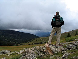
Below:
As you
head in to Wilder Gulch the trail gently ascends in and out of
some coniferous forests.
The pass
is off to the left in this photo. |
|
|

Check out Summit County Explorer's
"I LIKE TO BE ON TOP"
T-shirt and gear!
Click logo above
|
|
|
The trail
ascends steadily for about 2.9 miles from the parking lot in and
out of coniferous forests. Your goal is quite visible as you can
see the saddle straight ahead between Ptarmigian Hill (on the
right) and Machine Gun Ridge. At
about 2.9 miles you pick up a 4wd road on your left to begin the
final push to the pass. A sign clearly marks the location of
this turn. As you approach the pass, pristine meadows filled
with wildflowers mark the way. At the top of the pass toward
machine gun ridge on your left, look for a sign that has toppled
to the ground that describes the landmarks in view including
12,100' Ptarmigian Hill to your right. |

|
 |
The 1,200'
elevation gain and the 7 mile roundtrip distance make this an
intermediate level hike over relatively simple terrain.
Camp Hale, the training grounds for
the 110th mountain division that fought in the Alps during WWII
lies ahead. |
 |
|
|
|
|
Above:
After about 2.9 miles a sign marks a left turn that begins
the final ascent to the 11,800' pass. |
Above:
The final stretch - nearing the top. |
|
|
|
|
 |
Please Note:
In recent years, live ordnance has been found in the area
surrounding the camp so it is not advisable to explore in that
area. |
 |
|
|
|
|
|
Above:
Incredible wildflowers! |
Above:
Machine gun ridge where the famous
110th mountain division trained during WWII. |
|
|
|
|
|
|
|
|
|
|

|
beginner
|
|
intermediate
|
|
advanced
|
|
|
|
Black
Powder Pass
|
|
Mohawk
Lake
|
|
Quandary
Peak
14,265' |
|
|
|
Lily
Pad
|
|
Chihuahua
Gulch
|
|
Lincoln & Bross
14,291' / 14,177' |
|
|
|
St.
John's
|
|
Mt.
Royal
|
|
Bierstadt Peak
14,060' |
|
|
|
Mayflower Gulch |
|
Wheeler Lakes |
|
Willow & Salmon Lakes |
|
|
|
Loveland Pass |
|
Radical Hill Trail |
|
Upper Crystal Lake |
|
|
|
Salt Lick
Trail |
|
McCullough Gulch |
|
Gray's & Torrey's
14,278' / 14,267' |
|
|
|
Mesa
Cortina Trail |
|
Mt.
Sniktau |
|
Mt. Democrat
14,152' |
|
|
|
St. Mary's Glacier |
|
North
Ten Mile Trail |
|
Mt.
Victoria |
|
|
|
Sally Barber Mine |
|
Willow
Falls |
|
Mt.
Elbert
14,433' |
|
|
|
Oro
Grande Trail |
|
Eaglesmere Lakes |
|
Buffalo Mountain
12,777' |
|
|
|
Meadow Creek-Salt Lick |
|
Mosquito Pass |
|
Eccles Pass |
|
|
|
Shrine Mountain
Trail |
|
Webster Pass |
|
Mt. Huron 14,003' |
|
|
|
Ptarmigan Trail |
|
Ptarmigan via Wilder Gulch |
|
|
|
|
|
Peaks Tr. Barton Gulch |
|
Wheeler
Lake - Park County |
|
|
|
|
|
Hoosier Pass Loop |
|
Lenawee
Trail |
|
|
|
|
|
Spruce Creek Loop |
NEW! |
Nightmare on Baldy Mine |
|
|
|
|
NEW! |
Tenderfoot
Mountain Trail |
|
|
|
|
|
|
|
Did You find our FREE trail descriptions useful?
Please donate a buck or
two.
We appreciate your support! |
 |
|
|
|
|
|
|
|
|
|
|
|
|
|