|
|
 |
 
|
Below:
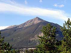
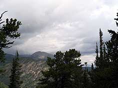
View of Peak One and Victoria from the east. Victoria is the
bald knob in the center of the picture. |
|
|

|
|
Description:
This hike involves more
elevation gain than an ascent of 14er Mt. Democrat from Kite
Lake. While you do not need to be a veteran of iron man
competition or Leadville's 100 mile marathon to complete this
trek, be advised that if your idea of exercise is a vigorous
game of miniature golf, you may wish to reconsider.
At the Mt. Royal trailhead you begin a steady
ascent to some mining ruins at old Masontown which is about a
half mile up the trail. Prior to arriving at the ruins you will
pass two trails that fork off to your left - avoid each and
continue up to the ruins. |
|
 |
As you continue through
beautiful stands of Aspen, a series of switchbacks brings you to
the Mt. Royal cut off about a mile from the trailhead. The trail
to Mt. Royal goes to the right so you need to continue straight
ahead. After leaving the aspen, you will encounter the ruins of
an old log cabin on your right. |
 |
|
|
|
|
|
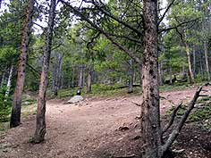
Above:
Before leaving the aspens, the trail divides as the Mt. Royal
cutoff goes to the right and the trail to Victoria continues
straight ahead. This is a little over a mile from the trailhead. |
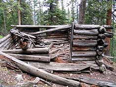
Above: After leaving the aspens the ruins of an old cabin appear
on the right. Walk around the cabin for great views of Buffalo
Mtn. |
|
|
|
|
 |
This is a good place to stop,
catch your breath and enjoy the great view of Buffalo Mountain.
Now the trail becomes steeper as you ascend a ledge and
eventually emerges from the forest where you will see a
communications facility perched on a knoll. The trail leads to
this facility from which you will follow the |
 |
|
|
|
|
|
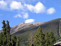
Above: A view of Buffalo Mtn. near the cabin. The trail becomes
steeper as you ascend up the slope. |
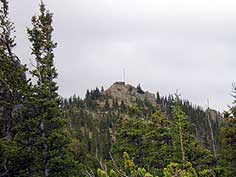
Above: As you finish a sttep climb up the ridge a view of a
communications facility emerges. It's not much farther! |
|
|
|
|
 |
ridge across an alpine meadow
to your destination - the rocky domes just ahead.
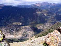
As you arrive at the summit you will enjoy spectacular views of
Frisco, Lake Dillon, Peak One and Uneva Lake. |
 |
|
|
|
|
|
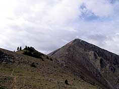
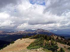
Above: Looking towards the summit of Mt. Victoria. (Peak one in
background - right) |
|
Above: Almost
there! |
|
|
|
|
 |
If you are thinking of
continuing on to Peak One be advised that it involves another
900' of elevation gain and crosses some dangerous and difficult
terrain. |
 |
|
|
|
|
|
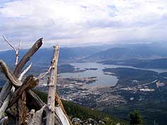
Above: beautiful view of lake Dillon taken from near the summit |
|
Above: Glimpses of seldom seen private Lake Uneva from
Victoria's summit. |
|
|
|
|
 |
Purchase a copy of National
Geographic's Topo Map of "Vail, Frisco & Dillon" from Weber's
bookstore in Breckenridge to fully enjoy this invigorating hike!
|
 |
|
|
|
|
|
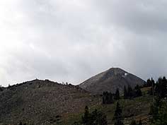
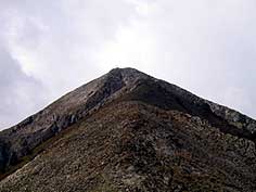
Above:
Peak One from the summit of Mt. Victoria |
Above: Looking back to the communications
facility from the summit. |
|
|
|
|
| |
 |
<<
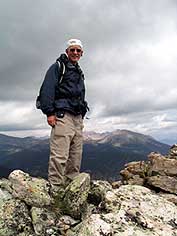
Left: The summit of Victoria -
"WE LIKE TO BE ON TOP!"

Click logo to Check out
Summit County Explorer's
"I LIKE TO BE ON TOP"
T-shirts and gear! |
|
|
|
|
|
|
|
|
|
|
|
|
|
|
|
|
|
|

|
beginner
|
|
intermediate
|
|
advanced
|
|
|
|
Black
Powder Pass
|
|
Mohawk
Lake
|
|
Quandary
Peak
14,265' |
|
|
|
Lily
Pad
|
|
Chihuahua
Gulch
|
|
Lincoln & Bross
14,291' / 14,177' |
|
|
|
St.
John's
|
|
Mt.
Royal
|
|
Bierstadt Peak
14,060' |
|
|
|
Mayflower Gulch |
|
Wheeler Lakes |
|
Willow & Salmon Lakes |
|
|
|
Loveland Pass |
|
Radical Hill Trail |
|
Upper Crystal Lake |
|
|
|
Salt Lick
Trail |
|
McCullough Gulch |
|
Gray's & Torrey's
14,278' / 14,267' |
|
|
|
Mesa
Cortina Trail |
|
Mt.
Sniktau |
|
Mt. Democrat
14,152' |
|
|
|
St. Mary's Glacier |
|
North
Ten Mile Trail |
|
Mt.
Victoria |
|
|
|
Sally Barber Mine |
|
Willow
Falls |
|
Mt.
Elbert
14,433' |
|
|
|
Oro
Grande Trail |
|
Eaglesmere Lakes |
|
Buffalo Mountain
12,777' |
|
|
|
Meadow Creek-Salt Lick |
|
Mosquito Pass |
|
Eccles Pass |
|
|
|
Shrine Mountain
Trail |
|
Webster Pass |
|
Mt. Huron 14,003' |
|
|
|
Ptarmigan Trail |
|
Ptarmigan via Wilder Gulch |
|
|
|
|
|
Peaks Tr. Barton Gulch |
|
Wheeler
Lake - Park County |
|
|
|
|
|
Hoosier Pass Loop |
|
Lenawee
Trail |
|
|
|
|
|
Spruce Creek Loop |
NEW! |
Nightmare on Baldy Mine |
|
|
|
|
NEW! |
Tenderfoot
Mountain Trail |
|
|
|
|
|
|
|
Did You find our FREE trail descriptions useful?
Please donate a buck or
two.
We appreciate your support! |
 |
|
|
|
|
|
|
|
|
|
|
|
|
|