|

|
 |
SUMMIT MOUNTAIN
RENTALS
A
full-service property management company offering top quality
Breckenridge and Frisco vacation lodging in Summit County,
Colorado. Locally owned and operated, specializing in
personalized service & attention for our guests, and we�re happy
to help you find the perfect vacation rental for your mountain
getaway.
Click to visit
SummitRentals.com today! |
|
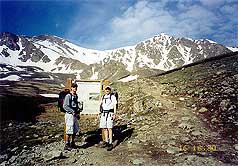
Below:
After 2 miles you reach Arapaho National Forest sign. The true
fun begins here! |
|
|

Check out Summit County Explorer's
"I LIKE TO BE ON TOP"
T-shirt and gear!
Click logo above
|
|
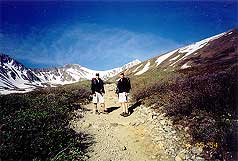
Description:
The first two miles ascend steadily back through the gulch via a
series of switchbacks. Spectacular wildflowers highlight this
section of the trail during July and August.
At two miles you reach an Arapaho
National Forest sign for Gray's National Recreation Trail. Here
you will begin to get clear views of Gray's on your left (south)
and the sharper peak of Torreys on the right. From this point
you will begin to experience the aerobic benefits of your hike.
As you ascend the rocky ridges ahead watch for mountain goats
that frequent the area. |
|
 |
Steep switchbacks take you all the
way to the summit. If you are looking for an additional
challenge, walk west off the summit and descend to the saddle
between Gray's and Torrey's where you can begin a steep half
mile climb to the top of Torrey's. |
 |
|
|
|
|
|
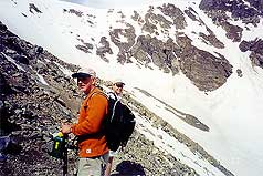
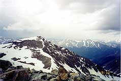
Above:
As you begin to gain altitude, The pathway becomes much steeper
and rockier. A beautiful bowl of snow is off to the right. |
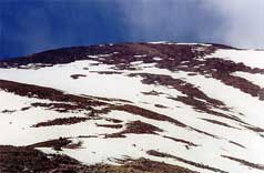
Above: Gray's
massive peak. A few hikers dot the snowfield providing a visual
reference for the true size of the peak. |
|
|
|
|
 |
For those who wish to bypass Gray's
you can stay on the trail to about 13,800' and then head
straight across some talus to the Gray's-Torrey's saddle. Be
aware that guide books caution you to avoid the snow
slope east of the saddle by staying above its south side (easily
seen as you approach the saddle). |
 |
|
|
|
|
|
Above: On
the peak of Grays, low clouds roll in and thunder is heard off
in the distance... |
|
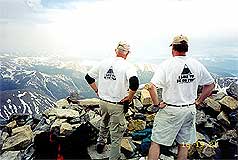
Above: A
quick shot of 2 SCE hikers in the rapidly disappearing blue
skies... |
|
|
|
|
 |
Numerous mishaps have occurred on
the slope - one described in a recent issue of Reader's Digest.
Whether you choose one summit or two, this hike will enable
everyone to understand why "we like to be on top." |
 |
|
|
|
|
|
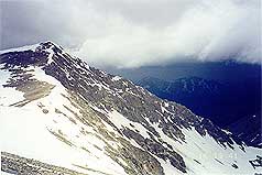
Above:
Looking over at Torrey's peak - the ominous clouds begin to roll
in. Hint: If your view looks similar to this, we would urge you
to descend immediately. |
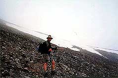
Ascending Torrey's during an approaching white out - note the
snow field on the saddle. Stay to the south (left) and above
this. Unfortunately white out conditions eliminated our chance
for additional views/photos. |
|
|
|
|
|
Just another word of caution:
compare the bottom photos with the top. How quickly the weather
changes at this altitude! When you see approaching cloud cover
and/or hear distant thunder, we urge you to descend to safety
immediately. Safety comes first, its best to live to climb
another day! |
|
|
|
|
|
|
|
|
|
|

|
beginner
|
|
intermediate
|
|
advanced
|
|
|
|
Black
Powder Pass
|
|
Mohawk
Lake
|
|
Quandary
Peak
14,265' |
|
|
|
Lily
Pad
|
|
Chihuahua
Gulch
|
|
Lincoln & Bross
14,291' / 14,177' |
|
|
|
St.
John's
|
|
Mt.
Royal
|
|
Bierstadt Peak
14,060' |
|
|
|
Mayflower Gulch |
|
Wheeler Lakes |
|
Willow & Salmon Lakes |
|
|
|
Loveland Pass |
|
Radical Hill Trail |
|
Upper Crystal Lake |
|
|
|
Salt Lick
Trail |
|
McCullough Gulch |
|
Gray's & Torrey's
14,278' / 14,267' |
|
|
|
Mesa
Cortina Trail |
|
Mt.
Sniktau |
|
Mt. Democrat
14,152' |
|
|
|
St. Mary's Glacier |
|
North
Ten Mile Trail |
|
Mt.
Victoria |
|
|
|
Sally Barber Mine |
|
Willow
Falls |
|
Mt.
Elbert
14,433' |
|
|
|
Oro
Grande Trail |
|
Eaglesmere Lakes |
|
Buffalo Mountain
12,777' |
|
|
|
Meadow Creek-Salt Lick |
|
Mosquito Pass |
|
Eccles Pass |
|
|
|
Shrine Mountain
Trail |
|
Webster Pass |
|
Mt. Huron 14,003' |
|
|
|
Ptarmigan Trail |
|
Ptarmigan via Wilder Gulch |
|
|
|
|
|
Peaks Tr. Barton Gulch |
|
Wheeler
Lake - Park County |
|
|
|
|
|
Hoosier Pass Loop |
|
Lenawee
Trail |
|
|
|
|
|
Spruce Creek Loop |
NEW! |
Nightmare on Baldy Mine |
|
|
|
|
NEW! |
Tenderfoot
Mountain Trail |
|
|
|
|
|
|
|
Did You find our FREE trail descriptions useful?
Please donate a buck or
two.
We appreciate your support! |
 |
|
|
|
|
|
|
|
|
|
|
|
|
|